What
is a Townland?
A
Brief Explanation of Ireland's Geographical Divisions
Karen
Dalton Preston
In Ireland, the townland is the
smallest territorial division of civil administration. Townlands can provide a
traceable location to the present day for our ancestors. They are also the key to knowing where to
look for records to trace your Irish ancestors.
You will spot townlands referenced
in virtually every historic record. Without it, you will find it difficult to
both find your ancestors in the records and make progress in differentiating
between entries for common names.
What can be very confusing when
researching Irish records is that the various land divisions are often
independent of one another - parts of an individual townland may lie across different
civil parishes and may also be in different Roman Catholic parishes and Church
of Ireland parishes, with ecclesiastical boundaries having no relationship to civil
parishes Even more frustrating is that
the same townland names also recur, and can be found in different parishes and
different counties, e.g. Newtown.
The term "townland" in
English is derived from the Old English word tün,
denoting an enclosure. The term describes the smallest unit of land division in
Ireland. The townland system is of medieval Gaelic origin, predating the Norman
invasion. Dating from medieval times or earlier, townlands were used to
identify a small area of land at a local level. The Normans left no major
traces in townland names, but they adapted some of them for their own use,
possibly seeing a similarity between the Gaelic baile
and the Norman "bailey", both of which meant a settlement.
The term baile,
anglicised as "bally", is the most dominant
element used in Irish townland names. Today, the term "bally" denotes
an urban settlement, but its precise meaning in ancient Ireland is unclear, as
towns had no place in Gaelic social organisation. The
modern Irish term for a townland is baile fearainn. The term fearann
means "land, territory, quarter".
Townlands cover the whole of the
island of Ireland (the Republic of Ireland in the south and Northern Ireland).
The total number of inhabited townlands in Ireland was 60,679 in 1911. The
total number recognised by the Placenames Database of
Ireland as of 2014 was 61,098, including uninhabited townlands. This database
can be very useful to locate a place name or townland name - https://www.logainm.ie/en/.
Townlands typically cover 100–500
acres. Most have Irish-derived names. However, some townland names and
boundaries come from the names of Norman manors, plantation divisions, or are
the later creations of the Ordnance Survey.
These divisions were used as the
basis for plantation grants in the sixteenth and seventeenth centuries, and
were considerably altered following subdivisions of the land. The townland was
used, not only for regular land transactions such as the imposition of rents,
but also as the primary division in major land valuations, surveys and census
such as the Tithe Applotment books (1823-1837) and
Griffith’s Valuation (1847-1864). Its significance now lies primarily in
enabling the identification of small, localised rural
areas.
Until the 19th century most
townlands were owned by single landlords and occupied by multiple tenants. The "cess", used to fund roadworks and other local
expenses, was charged at the same rate on each townland in a barony, regardless
of its size and productive capacity. Thus, occupiers in a small or poor
townland suffered in comparison to those of larger or more fertile townlands.
This was reformed by Griffith's Valuation.
In the 1800s the townlands were
mapped and defined by the English administration for the purpose of
confiscating land and apportioning it to investors or planters from Britain.
Irish Ordnance Survey and standardisation
During the 19th century an
extensive series of maps of Ireland was created by the Irish division of the
Ordnance Survey for taxation purposes. These maps both documented and standardised the boundaries of the more than 60,000
townlands in Ireland. The process often involved dividing or amalgamating
existing townlands, and defining townland boundaries in areas such as mountain
or bog that had previously been outside the townland system. Slight adjustments
are still made. There were 60,679 in 1911, compared to 60,462 townlands in
1901. To search for a townland for a particular county, go to https://www.townlands.ie
You will find several websites that
provide search functions for Griffith's Valuation, including maps of the
townland itself such as "AskAboutIreland"
at https://www.askaboutireland.ie/griffith-valuation/index.xml?action=nameSearch
Current use

A road sign in County Antrim,
Northern Ireland, notes that this part of the road lies within Teeshan townland.

A (rare) townland boundary marker
in Inishowen, County Donegal
Townlands form the building blocks
for higher-level administrative units such as civil parishes and district
electoral divisions (in the Republic of Ireland) or wards (in Northern
Ireland).
Townlands were also generally
grouped together to form other geographic layers, both civil and
ecclesiastical, as roughly portrayed below.
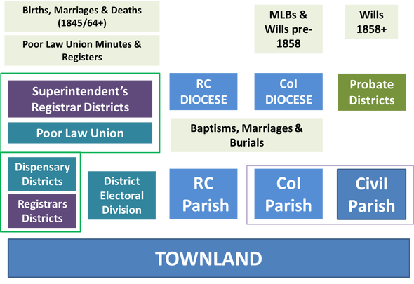
Note: In the chart above, "RC" = Roman
Catholic; "CoI" = Church of Ireland
Because townland names were
commonly found in more than one county in Ireland, you will need to know the
names of the land divisions in which your townland fell in order to isolate the
right records in a given record set.
There is one additional ancient land
division, the Barony. It predates all of
the other land divisions mentioned and largely fell out of general use. Having
said that, you will find them used in a host of land records and you will need
to know them for working out probate jurisdictions in the latter half of the
19th century.
The Irish Barony will be covered an a future article.
Sources:
Irish Genealogy website at
https://www.irish-geneaography.com/townlands.html
John Gresham's Irish research
website at https://www.johngrenham.com
RootsIreland at https://www.rootsireland.ie
Wikipedia at https://en.wikipedia.org/wiki/Townland